State Park · Arizona
Patagonia Lake State Park
- Location
- Santa Cruz County, Arizona
- Nearest town
- 7.4 miles east of Rio Rico
- Type
- State Park
About Patagonia Lake State Park
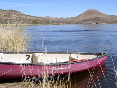
A dammed stretch of Sonoita Creek forms the 2.5-mile, 250-acre lake at the center of this park, a stocked fishery holding largemouth bass, black crappie, bluegill, catfish, and rainbow trout added every three weeks from October to March. The grounds also hold the Sonoita Creek State Natural Area, Arizona's first major state natural area, along with the creek itself, home to native Gila topminnows and Sonora suckers. Activities include fishing, camping, boat rental, hiking, and birding, and the park hosts an annual mariachi festival each March plus bird tours on request.
Hours, fees, camping, reservations and closures are set by the park and change often. Check the official park site before you go.
Getting there
Patagonia Lake State Park is in Santa Cruz County, Arizona, 7.4 miles east of Rio Rico. The Directions button takes you to the park's mapped location; the entrance may be elsewhere, so check the official site for the address to use.
State parks near Patagonia Lake State Park
Within 60 miles, closest first, straight-line. All 26 in Arizona →
Towns near Patagonia Lake State Park
State parks near Nogales, State parks near Sahuarita, State parks near Sierra Vista, State parks near Vail
Facts from Wikidata, checked September 25, 2026. Distances are straight-line.